Current Weather Outlook
Statewide weather outlook from Florida Division of Emergency Management Meteorology
Thursday, June 25, 2026
...Scattered Showers and Storms Along the I-10 Corridor Today and Throughout the Interior Peninsula... Any Storms will be Accompanied by Lightning, Gusty Winds, and Torrential Downpours... Marginal Risk (level 1 of 4) for Flash Flooding Outlooked for the Panhandle and Northern Big Bend... Highs in the Upper 80s to Middle 90s Statewide; Heat Indices in the 100s for the Peninsula but 90s for the Panhandle... Moderate Risk of Rip Currents Across Panhandle and Northeast Florida Beaches...Low Risk of Rip Currents Elsewhere... No Tropical Cyclone Activity Expected in the Next 7 Days in the Atlantic...
Updated at 9:10 AM EDT
Today's Threats:
|
No Threat |
Low Threat |
Medium Threat |
High Threat |
|
Lightning |
Tornado |
Damaging Wind/Hail |
Wildfire |
Excessive Heat |
Flash Flooding |
Fog (Overnight) |
Rip Currents |
|
Interior South FL I-10 Corridor & Central Peninsula West Coast
|
|
Iso. Statewide |
Iso. Peninsula |
Locally Statewide |
Panhandle & Northern Big Bend Iso. Peninsula |
|
Eastern Panhandle & Northeast FL Rest of Florida |
![]()
Weather Summary for the Next 24 Hours:
The cold front that settled across North Florida yesterday will begin to dissipate and lift back north today allowing abundant moisture to filter back into the region ahead of a remnant mid-level disturbance currently over the western Panhandle. This remnant disturbance currently producing a few showers and thunderstorms across the western Panhandle this morning will begin to trek eastward towards South Georgia today. Paired with the Gulf sea breezes, these features will promote the development of afternoon showers and thunderstorms along the I-10 corridor of the Panhandle and Big Bend (50-75% chance of rain). A few of these thunderstorms may become locally strong to severe and capable of producing frequent lightning, gusty winds (40-60 mph), and torrential downpours. These heavy downpours may lead to areas of nuisance flooding and ponding of water in urban and poor drainage locations and a Marginal Risk (level 1 of 4) for Flash Flooding is outlooked.
Throughout the Peninsula, another rinse and repeat day is expected with showers and thunderstorms developing along the East and West Coast sea breezes as they push inland, eventually colliding over the central Peninsula (50-75% chance of rain). The focus for activity is expected to be across interior South Florida (80-90% chance of rain). Although there is no organized risk for severe weather or flash flooding throughout the Peninsula, thunderstorm activity could become locally strong with gusty winds and heavy downpours the primary hazards. Rainfall amounts will generally remain below 1” for most locations, however locally higher totals upwards of 2-3” cannot be ruled out in areas that see repeated rounds of slow-moving storms.
High temperatures will climb into the upper 80s to middle 90s statewide this afternoon. Paired with the humidity, feels-like temperatures will top out in the lower to middle 100s throughout the Peninsula. Heat indices will remain in the 90s across the Panhandle given more cloud cover and rainfall this afternoon.

Tonight, shower and thunderstorm activity will linger into the evening hours before dissipating or pushing offshore after dark (25-40% chance of rain). Lows will fall into the 70s to lower 80s statewide.

![]()

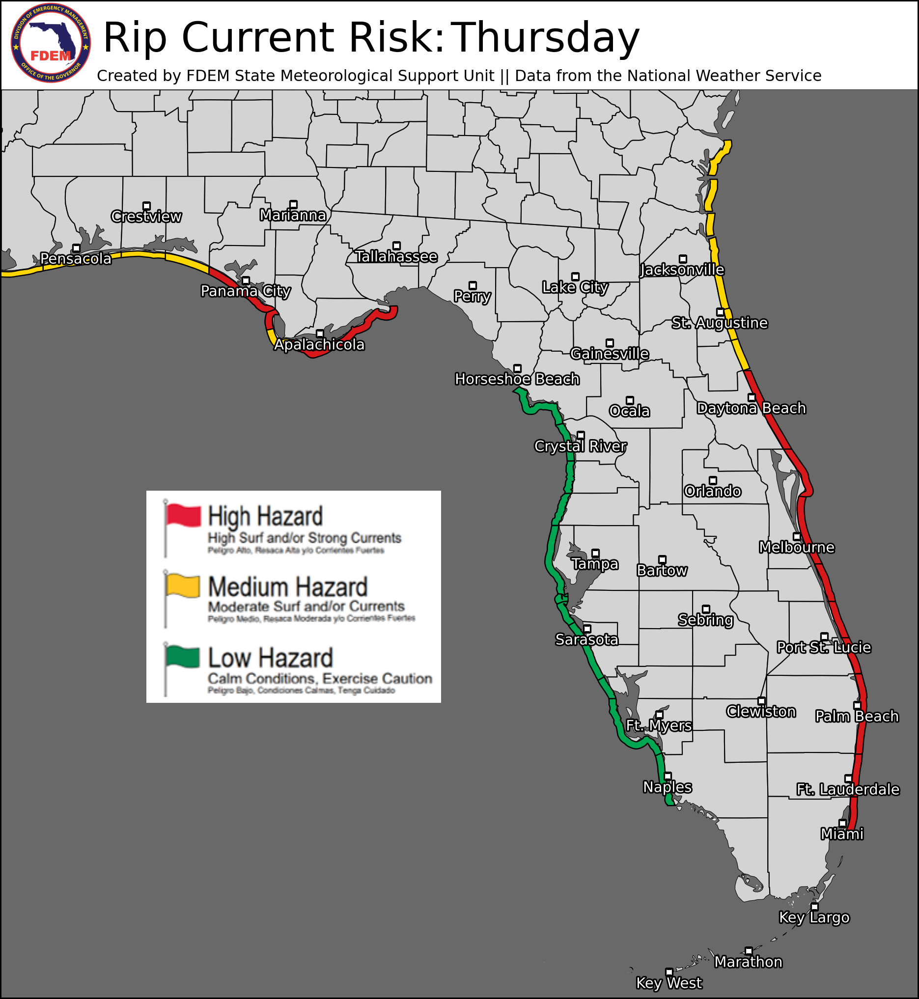
Rip Currents: A moderate risk for rip currents is outlooked for eastern Panhandle and Northeast Florida beaches today. A low risk is expected for all other beaches. For the latest Rip Current Outlook, visit www.weather.gov/beach.
Marine Hazards: Surf heights remain limited for all beaches today. The highest surf heights will be around 2-3’ across Northeast and Space Coast beaches. Surf heights of 1-2’ are expected for most other beaches today.
Red Tide: was observed at background concentrations offshore Pinellas and Hillsborough counties over the past week. It was not observed elsewhere across the state (valid 6/19/26).
Coastal Flooding: There are no current coastal flood alerts for the state.
![]()
Fire Weather: Moisture will begin to filter back into North Florida today as southwesterly flow increases ahead of a mid-level disturbance passing north of the region. Scattered showers and thunderstorms will develop later today which will keep relative humidities above critical thresholds and the overall wildfire threat low. Scattered showers and storms are also expected across the Peninsula today with a focus on Interior and Southwestern regions. Any thunderstorm could be accompanied by lightning and gusty/erratic winds, which can spark new wildfires or reignite existing ones. Much drier conditions have developed locally over West-Central Florida where a predominate westerly flow has kept thunderstorm activity off to the east. As such, locally sensitive wildfire conditions have developed here amidst ongoing extreme drought (level 3 of 4). Have expanded the area of locally sensitive wildfire conditions to include most of the Florida Peninsula as well to reflect the threat of lightning-based ignitions today and the uptick of fire activity seen across these areas in recent days. A few active wildfires across Southeast Florida may lead to dense smoke in and around the fires, leading to poor air quality. According to the Florida Forest Service, there are 71 active wildfires across the state burning approximately 43,290 acres.
Drought (6/23/26): It was a very wet week across much of the state as we saw a nearly stationary front bring repeated rounds of showers and thunderstorms to the I-10 corridor and active sea breezes promote daily showers and thunderstorms throughout the Peninsula. Some of the biggest changes on this weeks Drought Monitor update were observed across the Panhandle. Rainfall amounts between 4-8 inches, with locally as much as 12 inches in the northern Panhandle, has resulted in all moderate drought (level 1 of 4) west of the Apalachicola River to be downgraded to abnormally dry (receding drought) conditions. The far northern portions of these Panhandle counties, where the heaviest rainfall fell, have now been completely removed from any drought category. Rainfall departures here are now between 10-15 inches above normal or more in the last 90 days. Further east, much of the Big Bend and Suwannee River Valley received between 3-6 inches of rainfall over the course of the past week. This has resulted in all localized pockets of exceptional drought (level 4 of 4) to be downgraded to extreme drought (level 3 of 4) conditions. This area of extreme drought extends along the Forgotten Coast and into the upper Suwannee River Valley and interior Northeast Florida. Moderate to Severe Drought (level 1-2 of 4) surround this area across the remainder of the Big Bend, Northeast and North-Central Florida. Across the Peninsula, much of the extreme drought (level 3 of 4) along the West-Central coastline remains. Rainfall totals here over the past 7 days have been negligible, which has kept the persistent drought around. Sea breeze activity focused across East-Central Florida brought rainfall amounts of 2-4” last week, ridding coastal Brevard, Indian River, and St. Lucie counties of any drought category this week. Areas of moderate to severe drought (level 1-2 of 4) persist across much of the I-4 corridor and interior Central Florida. Pockets of extreme drought (level 3 of 4) are also found in southwestern Polk and central Hardee and DeSoto counties. In South Florida, heavy rains focused across the southwestern region bringing severe drought conditions down to moderate drought (level 1 of 4) along coastal Monroe and Collier counties, as well as interior Lee, Charlotte, Hendry, and Glades counties. Only a small pocket of severe to extreme drought (level 2-3 of 4) persists across interior Miami-Dade, Broward, Collier, and Hendry counties. Looking ahead, sea breeze showers and thunderstorms will largely persist daily across the state, especially focused across the Peninsula. A brief stretch of drier conditions is expected this weekend before increasing moisture returns to the state beginning on Monday. Some localized improvements in the drought are possible in areas that do see heavy rains. However, areas that fail to see the scattered rainfall will largely see drought conditions persist amidst hot summer temperatures.

The Keetch-Byram Drought Index average for Florida is 345 (+15) on a scale from 0 (very wet) to 800 (very dry). There are 10 out of 67 Florida counties that have an average KBDI above 500 (drought/increased fire danger).

![]()
Flash Flooding: A Marginal Risk (level 1 of 4) for Flash Flooding is outlooked across the northern Panhandle and Big Bend today where a remnant mid-level disturbance passing north of the region, paired with the Gulf sea breezes, will promote scattered showers and thunderstorms this afternoon. A few storms could produce locally heavy downpours and lead to nuisance flooding and ponding of water, mainly in urban and poor drainage locations. Although there is no organized risk for flash flooding throughout the Peninsula, slow-moving afternoon thunderstorms may also lead to localized urban flooding. Rainfall amounts will generally remain below 1” for most locations, however locally higher totals upwards of 2-3” cannot be ruled out.

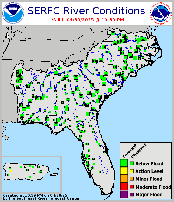
Riverine Flooding: Water levels have begun to slowly recede across much of the western Panhandle following the episode of flash flooding late last week and weekend. Many rivers, creeks, and streams have diminished back down to Action Stage (bank-full). However, the Escambia River near Century and Choctawatchee River near Bruce-Ebro both remain in minor flood stage and are forecast to remain there until this weekend. River Flood Warnings remain in effect for the Escambia River near Century and Choctawhatchee River near Bruce. For more information, visit the River Forecast Center.
Lake Okeechobee’s average elevation is 10.97 feet, which is within the operational band and is 2.30 feet below normal for this time of year.