RSS 5 Day Weather Outlook
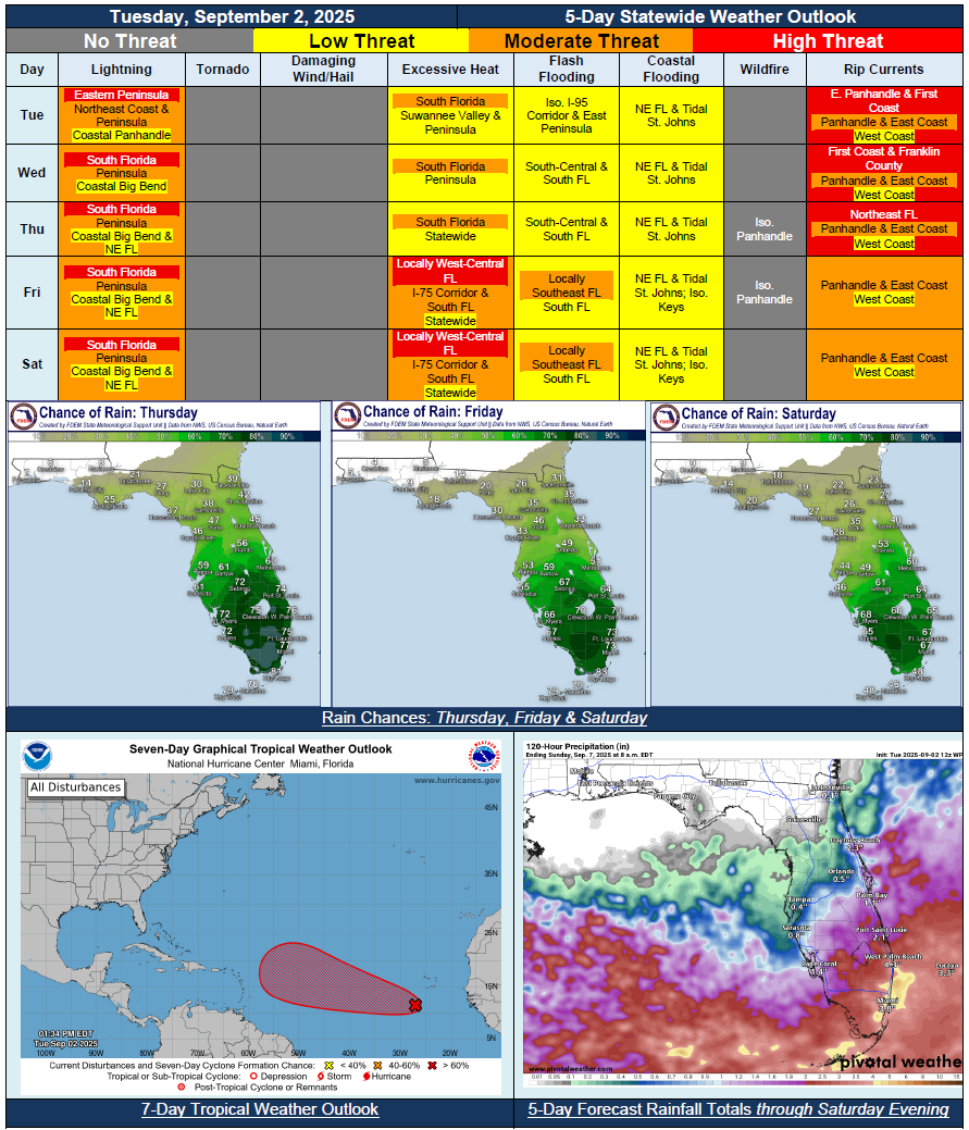
5 Day Statewide Weather Outlook for Tue. 9/2 to Sat. 9/6
You are subscribed to 5 Day Weather Outlook for Florida Division of Emergency Management. This information has recently been updated, and is now available.
…Dry Conditions Return Across Panhandle; Isolated Activity Limited to Sea Breeze Pinned Along the Coast…Stalled Frontal Boundary and Upper-Level Disturbance To Create Wet and Active Weather Pattern Throughout the Peninsula Each Day…Marginal Risk for Flash Flooding Begins Wednesday and Continues Through Saturday Across South Florida…Shifts In the Front Could Shift Rain Chances North or South…General Warming Trend Expected Throughout the Week; Triple Digit Heat Index Values Return Nearly Statewide By Saturday…King Tides Developing Later This Week Ahead of Next Full Moon; Instances of Minor Coastal and Tidal Flooding Possible During Times of High Tide…Coastal Flood Advisories Already In Place for Tidal St. Johns River Due to Trapped Tides…Next Tropical Wave Moving Off African Coast Has High (70%) Chance for Development Over Next 7 Days – No Threat to Florida At This Time…
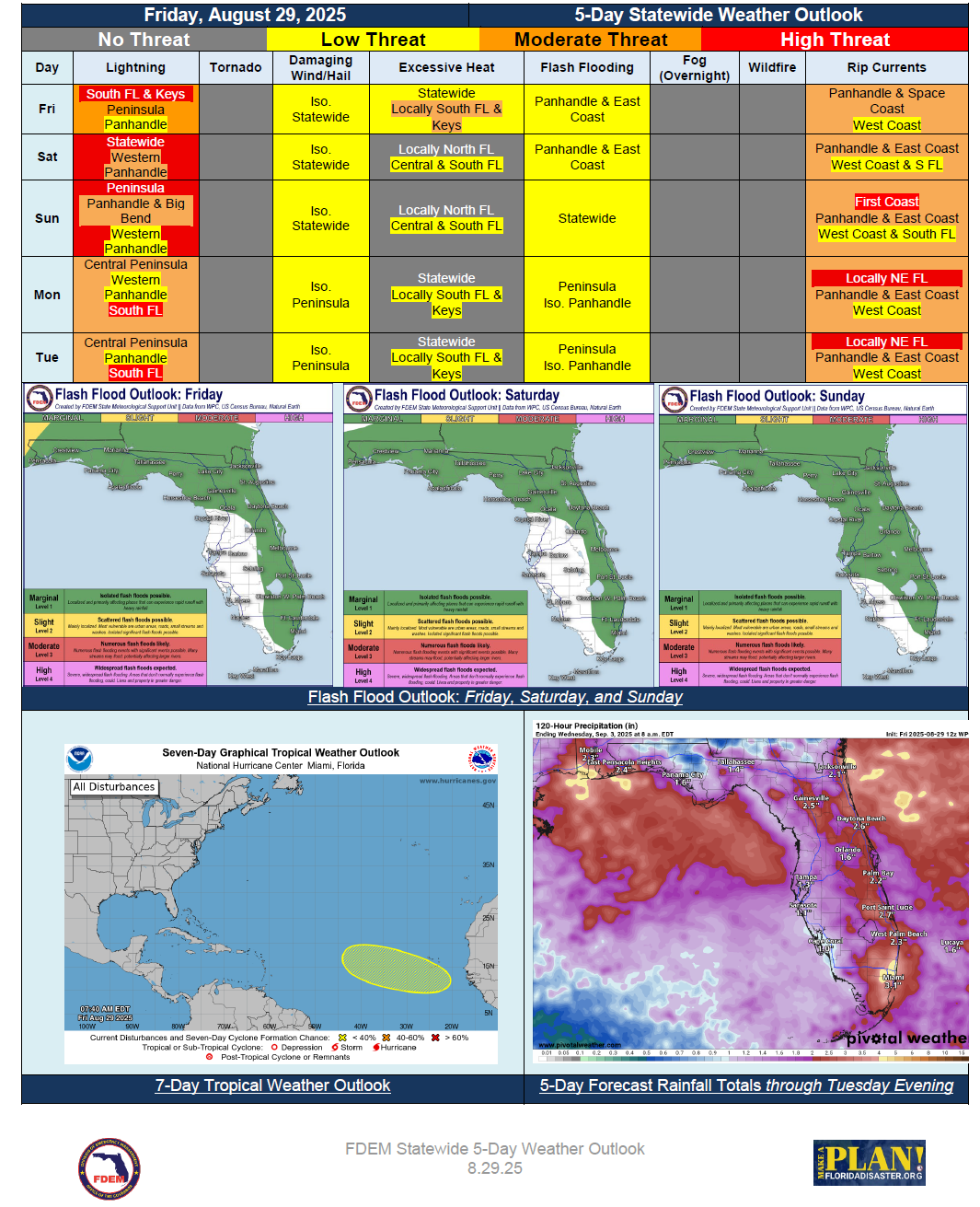
5 Day Statewide Weather Outlook for Fri. 8/29 to Tue. 9/2
You are subscribed to 5 Day Weather Outlook for Florida Division of Emergency Management. This information has recently been updated, and is now available.
…Wet and Unsettled Conditions Return as a Stationary Front Stalls Across North Florida…Daily Shower and Thunderstorm Activity Expected Statewide…Marginal Risk for Flash Flooding Outlooked Each Day… Locally Embedded Strong to Severe Thunderstorms Possible… Some Drier Air Enters Northern Panhandle By Monday... Heat Index Values Remain Below Triple Digits Across North and Central Florida… South Florida May See Localized Triple Digit Heat Indices… Football Forecasts Return…
5 Day Statewide Weather Outlook for Tue. 8/26 to Sat. 8/30
You are subscribed to 5 Day Weather Outlook for Florida Division of Emergency Management. This information has recently been updated, and is now available.
…Dry Conditions Return Through Midweek Across North Florida In Wake of Passing Cool Front…Shower and Thunderstorm Activity to Remain Mostly Concentrated Along and South of I-4 Corridor Through Wednesday and Thursday…Another Front Approaches and Moves Into the State Friday and Saturday…Increasing Moisture Will Allow for Rain Chances to Expand Northward Through End of the Week…Widespread Rainfall Anticipated Statewide By Saturday…Heat Index Values Fall Below Triple Digits Across North Florida this Week; Triple Digits Continue for Portions of Peninsula this Week…Flash Flood Chances Increasing Friday and Saturday Throughout North and Central Florida With Increase Rain Chances…Football Forecasts Return…
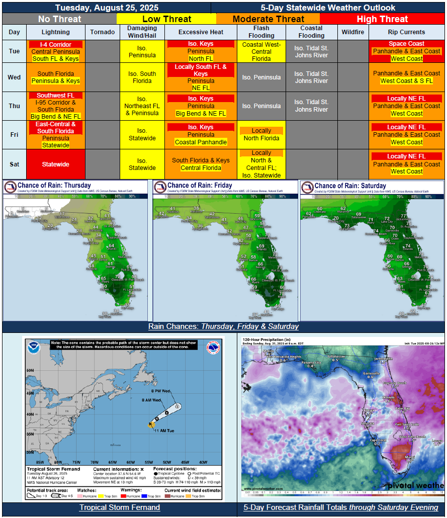
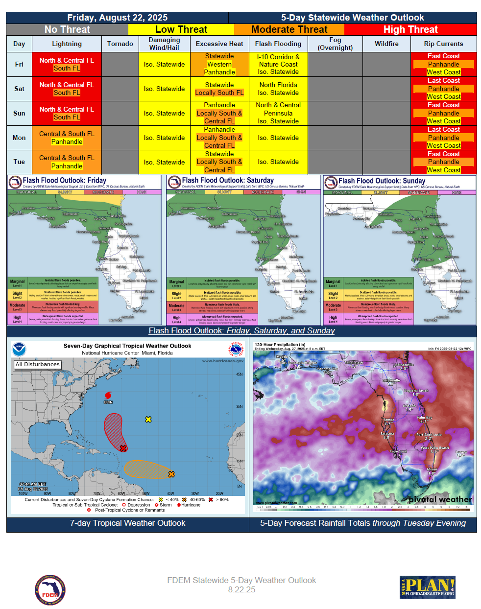
5 Day Statewide Weather Outlook for Fri. 8/22 to Tue 8/26
You are subscribed to 5 Day Weather Outlook for Florida Division of Emergency Management. This information has recently been updated, and is now available.
...Stalled Front in the Wake of Erin to Bring Wet and Unsettled Weather Across the State… Flash
Flooding Possible Over North Florida and I-10 Corridor Through the Weekend… Front Slowly
Drifts South Early Next Week Along With Greatest Rainfall Chances… Warm and Muggy
Conditions Persist Through Sunday… Possible Late Summer Cold Front Approaches North
Florida Monday Bringing Some Relief From Heat and Rainfall to Start Next Week… Dangerous
Rip Current Threat and Elevated Surf Remains from Distant Hurricane Erin…
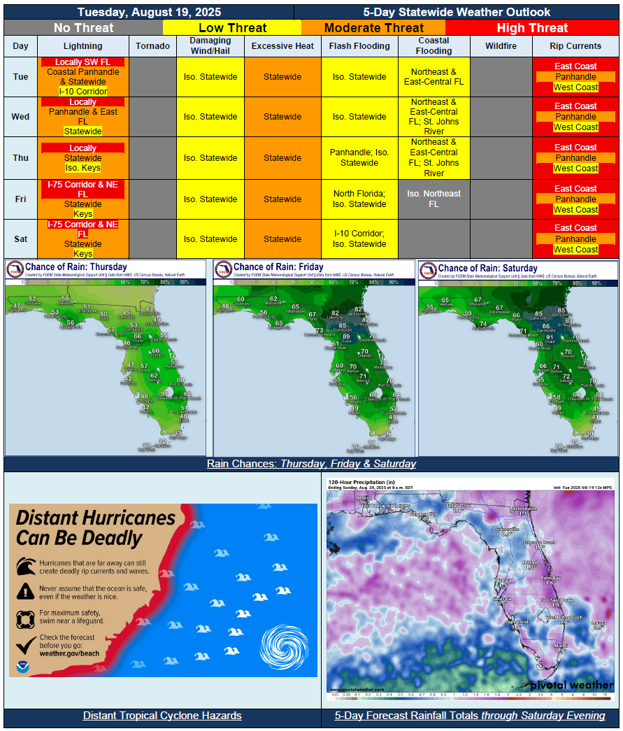
5 Day Statewide Weather Outlook for Tue. 8/19 to Sat. 8/23
You are subscribed to 5 Day Weather Outlook for Florida Division of Emergency Management. This information has recently been updated, and is now available.
…Distant Hurricane Erin Bringing Breezy Winds Along Florida East Coast Through Midweek…Slightly Drier Air Keeping Shower and Thunderstorm Activity Scattered Tuesday and Wednesday…Approaching Front to Increase Rain Chances Beginning Thursday, But More So Friday and Saturday…Increased Potential for Localized Flash Flooding and Ponding of Water Across North Florida Friday and Saturday As Front Begins to Stall…Triple Digit Heat Index Values Expected Daily; Just Below Heat Advisory Criteria…Life-Threatening and Extremely Dangerous Beach Conditions and Rip Currents Along the Florida East Coast Throughout the Forecast Period Due to Distant Hurricane Erin Remaining Well Offshore…Instances of Minor Coastal Flooding and Beach Erosion Possible Too…