Current Weather Outlook
Statewide weather outlook from Florida Division of Emergency Management Meteorology
Tuesday, April 1, 2025
...Foggy Conditions and Low Clouds Throughout the State this Morning; Dense Fog Advisories in Effect Through Mid-Morning Hours Across Much of North Florida...Sea Fog May Linger Near and Along West-Central Florida Coast...Mostly Dry Conditions Return Across Panhandle and Big Bend...Sea Breeze Showers and Thunderstorms to Develop this Afternoon and Evening; Locally Strong Thunderstorms Possible During Peak Heating Hours...Isolated Lingering Showers Possible to Continue Overnight, Especially Northeast Florida...Fog Development Likely Overnight and Into Wednesday Morning; Locally Dense Fog Possible...Moderate to High Risk for Rip Currents Along Panhandle; Moderate Risk for Numerous East Coast Beaches...
Updated at 10:09 AM EST
Today's Threats:
|
No Threat |
Low Threat |
Medium Threat |
High Threat |
|
Lightning |
Tornado |
Damaging Wind/Hail |
Excessive Heat |
Flash Flooding |
Fire Weather |
Fog (Overnight) |
Rip Currents |
| Northeast Florida & Peninsula |
Locally Iso. Northeast Florida & Peninsula |
Iso. Interior Peninsula |
Locally Iso. Northeast Florida & Peninsula |
Locally West Florida Statewide
|
Panhandle East Coast Southeast Florida & West Coast |
![]()
Weather Summary for the Next 24 Hours:
Fog and low clouds are scattered throughout the Sunshine State this morning, and Dense Fog Advisories are in effect throughout much of North Florida until the mid-morning hours due to reduced visibility of ¼ of a mile or less. Foggy conditions and cloud cover will linger through the mid-morning hours before lifting and dissipating; however, instances of sea fog may linger over the coastal waters and near the coastline along West-Central Florida.
Yesterday’s cold front will linger over North Florida before becoming stalled near the state line this afternoon. Mostly dry conditions can be expected across the Panhandle and Big Bend throughout the daytime hours, with a chance for a few isolated showers over the Suwannee Valley and I-75 corridor. Throughout Northeast Florida and the Peninsula, lingering moisture ahead of the front and the sea breeze developing this afternoon and evening will allow for isolated to widely scattered showers and embedded thunderstorms (10-35% chance of rain). Severe weather is not expected today, but locally strong thunderstorms may be possible during the peak heating hours of the day near and along the sea breeze collision. Any stronger thunderstorm that develops will be capable of producing lightning, gusty winds and locally heavy rainfall.
High temperatures this afternoon will rise into the middle to upper 80s and lower 90s throughout the state. Coastal areas will be slightly cooler compared to inland areas due to the sea breeze. Feels-like temperatures will reach the lower 90s throughout interior regions of the Peninsula with increased moisture and warmer temperatures.

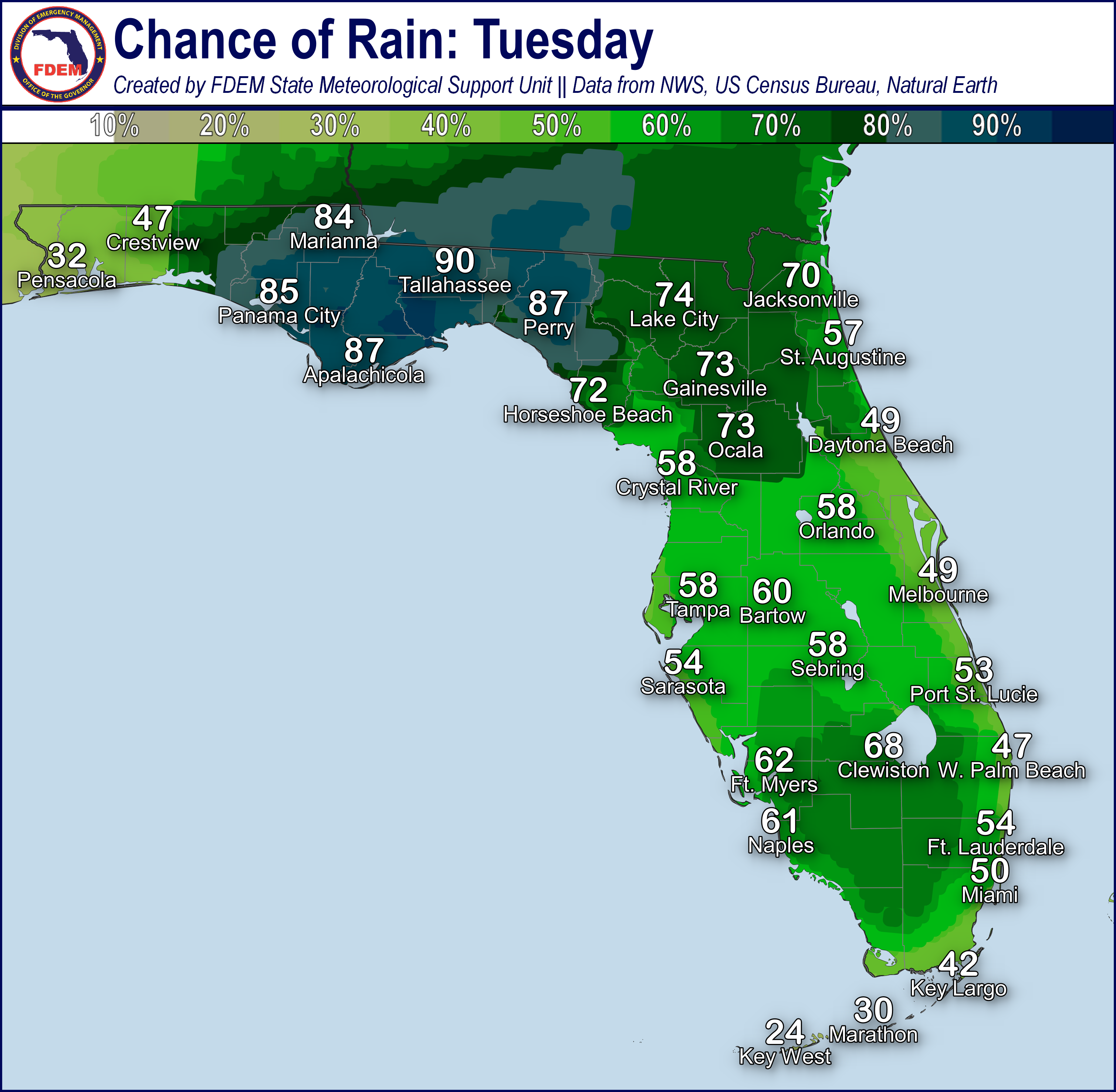
Any showers and thunderstorms that develop with the sea breeze will linger into the evening hours before pushing offshore and dissipating over the adjacent waters. The frontal boundary over the state line will begin to lift northward this evening and overnight as it transitions to a warm front, but a few showers may continue overnight near the warm front (15-25% chance of rain). Calm conditions and lingering moisture will give way to another round of fog development across the state, with locally dense fog possible across West Florida, overnight and into Wednesday morning.
Low temperatures will fall into the middle to upper 60s and lower 70s throughout the state.

![]()

Rip Currents: Onshore winds along the Panhandle will create a moderate to high risk for rip currents along all beaches. Numerous East Coast beaches through the Space Coast can also expect a moderate risk for rip currents. All other beaches can anticipate a low risk. With spring break season is full-swing, messaging regarding rip currents and dangerous surf conditions should be maintained for visitors and tourists. For the latest Rip Current Outlook, visit www.weather.gov/beach.
Marine Hazards: Wave heights of 1-3’ can be expected across the state, with breaking waves upwards of 4’ offshore in the surf zone near Northeast Florida coast beaches.
Red Tide has been observed at background levels in 1 samples collected from Northwest Florida (Gulf County) over the past week (valid 3/29). There have been no reports of respiratory irritation or fish kills suspected to be related to red tide.
Coastal Flooding: There is no risk for coastal flooding today.
![]()
Fire Weather: Foggy conditions and low clouds are scattered throughout the state this morning and will linger through the mid-morning hours. Dense Fog Advisories extend across much of North Florida due to dense fog reducing visibility to ¼ of a mile or less at times. Instances of sea fog may linger into the afternoon hours near the West-Central Florida coast and coastal waters. Moisture will linger through today across the state as a frontal boundary becomes draped near the state line and southerly to southeasterly winds persist. Drier conditions across interior portions of Southwest Florida will allow for relative humidity values to fall near critical thresholds this afternoon (40-45%). Light winds and wind gusts can be expected throughout the state during the daytime hours. Sea breeze showers and embedded thunderstorms will be possible this afternoon and evening throughout the Peninsula. Thunderstorms will be capable of producing lightning and erratic winds. Calm conditions and lingering moisture overnight will allow for another round of fog and low clouds to develop by sunrise Wednesday morning throughout the state, with instances of locally dense fog across West Florida. Foggy conditions may further reduce visibility where there are ongoing wildfires. According to the Florida Forest Service, there are 41 active wildfires across the state burning approximately 28,586 acres.

Drought: Most of the Southeast U.S. experienced a dry, breezy week, leading to a rash of wildfires and general increases in the coverage of Abnormally Dry (emerging drought) and Moderate to Severe Drought conditions on this week’s Drought Monitor update (valid 3/27). Severe Drought condition also persist across much of South Florida and north of the I-4 corridor across portions of the Nature Coast. Abnormally Dry to Moderate Drought conditions expand elsewhere across the Peninsula from a line from Horseshoe Beach to Gainesville to St. Augustine and southward through the far southern Peninsula. In Southern Florida, the 344 Fire near Homestead grew to nearly 27,000 acres, with containment reaching 80% by 3/25. The Climate Prediction Center (CPC) is outlooking above normal temperatures and slightly above normal rainfall across the Peninsula over the next week or so which may allow drought conditions to hold steady.
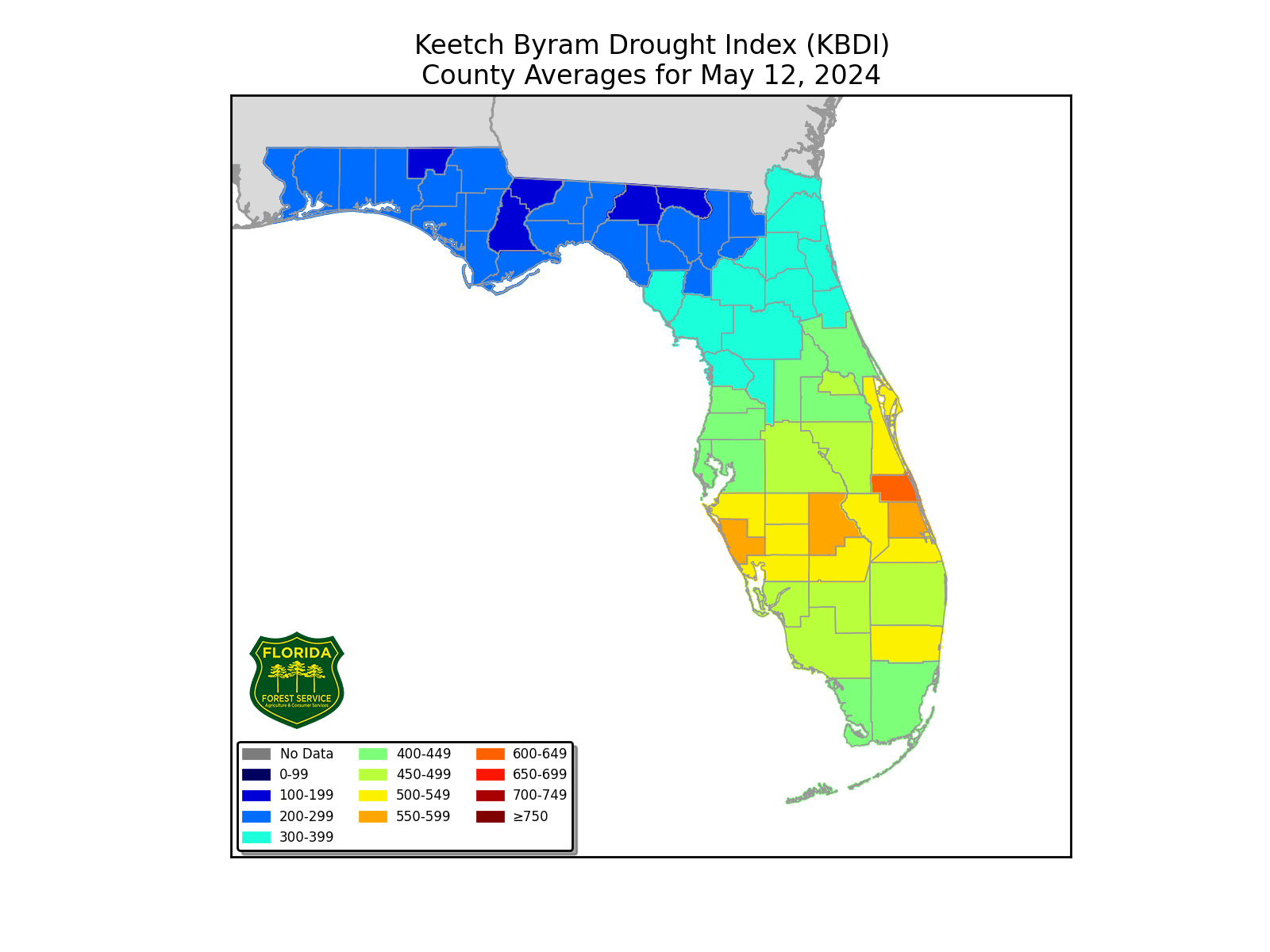
The Keetch-Byram Drought Index average for Florida is 312 (-42) on a scale from 0 (very wet) to 800 (very dry). There are 15 Florida counties (Broward, Charlotte, Collier, Glades, Hardee, Hendry, Lake, Lee, Manatee, Miami-Dade, Monroe, Palm Beach, Sarasota, and Sumter) with an average KBDI over 500 (drought/increased fire danger).
![]()
Flash Flooding: There is no organized risk for flash flooding today. Sea breeze showers and embedded thunderstorms will be capable of producing locally heavy rainfall throughout the Peninsula that could lead to instances of localized flooding and ponding of water over urban and low-lying/poor drainage areas. Areas that have recently seen heavy rainfall over the last couple of days could seen a quicker onset for localized flooding should any additional heavy downpours develop over those same areas. Rainfall totals will generally remain near 1”; however, locally higher totals upwards of 1-3” cannot be ruled out.

Riverine Flooding: Recent heavy rainfall has allowed for water levels within the Perdido River to rise into Action Stage (bank-full). The Aucilla and Santa Fe basins also remain elevated within Action Stage (bank-full). River flooding is not expected at this time. There are no additional riverine concerns at this time. For more information, visit the River Forecast Center.
Lake Okeechobee’s average elevation is 12.56 feet, which is within the operational band and is 1.75 feet below normal for this time of year.
