Lightning

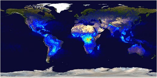
Annual lightning flash density across the globe. Note the highest concentration is
over Central Africa, but Florida also experiences a great deal of lightning.
Lightning occurs with every thunderstorm and, on average, Florida sees around 70-100 days a year with at least one thunderstorm in the state. Because of Florida's vulnerability to thunderstorms and lightning, lightning is one of the most deadly weather hazards in the Sunshine State.
In order to tell how close a lightning strike is, count the seconds between the lightning flash and the resulting thunder. For every five seconds you count, lightning is one mile away. A good rule of thumb with regards to lightning safety is to remember that if you can hear thunder, you are close enough to be struck by lightning. Even if it is not raining where you are, lightning can still reach you. Lightning can travel as far as 10 miles away from its thunderstorm, and has been observed as far as 25 miles away. This is why the best thing you can do when you see lightning is seek safe shelter as soon as possible.
Although meteorologists can predict the general conditions needed to produce lightning, no one can forecast exactly where and when the next strike of lightning will hit. Therefore, if you know that thunderstorms are in the forecast, you know that lightning is, too.
Convective Outlooks: The Storm Prediction Center issues forecasts based on the potential for organized severe thunderstorms. The outlooks show the areas where severe thunderstorms may develop and qualifies the degree of risk. A SLGT (slight) risk implies that well-organized severe thunderstorms are expected but in relatively small numbers, or a small chance of a more significant severe event. A MDT (moderate) risk implies a greater concentration of severe thunderstorms, and in most situations, greater magnitude of severe weather and greater forecaster confidence compared to a SLGT risk. A MDT risk is usually reserved for days with an enhanced chance for a significant severe storm outbreak. The HIGH risk implies that a major severe weather outbreak is expected, with large coverage of severe weather and the likelihood of extreme severe (i.e., violent tornadoes or very damaging wind events). The HIGH risk category is only used a few times each year. In addition to the severe risk areas, general thunderstorms (non-severe) are outlined in green on the map.
Hazardous Weather Outlook - A statement produced by the local National Weather Service offices to provide information regarding the potential of significant weather expected during the next week. This is issued to advise storm spotters and emergency managers of potentially hazardous weather and other threatening conditions.
Graphical Hazardous Weather Outlook - A graphic issued by some National Weather Service Offices that shows the potential for lightning and other weather threats on the current day.
Graphical Hazardous Weather Outlooks can be found from the following National Weather Service Offices:
Tallahassee, Tampa, Melbourne, and Miami.
Short Term Forecast - Issued by the National Weather Service as a 1-2 hour forecast of local weather conditions; emphasizing hazardous weather.
Severe Thunderstorm Watch - Issued by the Storm Prediction Center to alert the public that conditions are favorable for the development of severe thunderstorms in and close to the watch area. These watches are issued with information concerning the watch area and the length of time they are in effect. During the watch, people should review severe thunderstorm and lightning safety rules and be prepared to move a place of safety if threatening weather approaches.
- Have a NOAA All-Hazards Weather Radio and battery backup to receive important weather and other emergency-related warnings. With a NOAA All-Hazards Weather Radio, you can monitor current weather conditions and forecasts for your local area. These radios also have an alert feature which will sound an alarm - followed by important weather information - whenever a watch or warning is issued for your area.
- Inquire if your Community is StormReady. StormReady helps community leaders and emergency managers strengthen local safety programs. StormReady communities are better prepared to save lives from the onslaught of severe weather through advanced planning, education and awareness.
- Check the weather forecast before leaving for extended periods outdoors and watch for signs of approaching storms while outside. Postpone outdoor activities if storms are imminent.
- Discuss lightning safety with all members of your household or business.

