Current Weather Outlook
Statewide weather outlook from Florida Division of Emergency Management MeteorologySaturday, May 18, 2024
...One More Potential Round of Strong to Severe Thunderstorms Has Begun to Develop and Is Moving Eastward Through the Florida Panhandle...Additional Showers and Thunderstorms To Develop Along the Peninsula With the Sea Breeze...Slight Risk For Severe Weather Across North Florida; Marginal Risk Along the East and West Coasts...Damaging Wind Gusts, Instances of Hail, Isolated Tornadoes, and Heavy Downpours Possible...Marginal to Slight Risk For Flash Flooding Across North Florida...Flood Watches Remain in Effect Along the Florida Panhandle Until This Evening As Additional Instances of Flooding and Ponding of Water Will Be Possible, Especially With Grounds Already Saturdated...Scattered Showers and Thunderstorms To Persist Overnight Into Sunday...Heat Advisories Issued For South Florida, the Keys, and The Central-East Coast for Heat Indices of 106-110-Degrees; Heat Indices Near 97-105-Degrees Elsewhere Through the Peninsula...River Flood Warning Issued For Several Florida Panhandle Rivers As Minor Flooding Is Expected...Sensitive Wildfire Conditions Possible Along Portions of the Interior Peninsula...High Risk For Rip Currents Along Panhandle; Moderate Risk Along West Coast...Areas of Patchy to Locally Dense Fog Possible Overnight Into Early Sunday Morning...
Updated at 9:39 AM EDT
Today's Threats:
| No Threat | Low Threat | Medium Threat | High Threat |
| Lightning | Tornado | Damaging Wind | Hail | Flash Flooding | Excessive Heat | Wildfire | Rip Currents |
|
Locally N FL, W & E Coast Statewide |
N FL & E-Coast |
North Florida W & E Coast |
N FL & E-Coast |
Panhandle & W-Big Bend North Florida |
S FL, Keys, & E-Coast Peninsula |
Int. Central Florida |
Panhandle W-Central Coast East Coast |
![]()
Weather Summary for the Next 24 Hours:
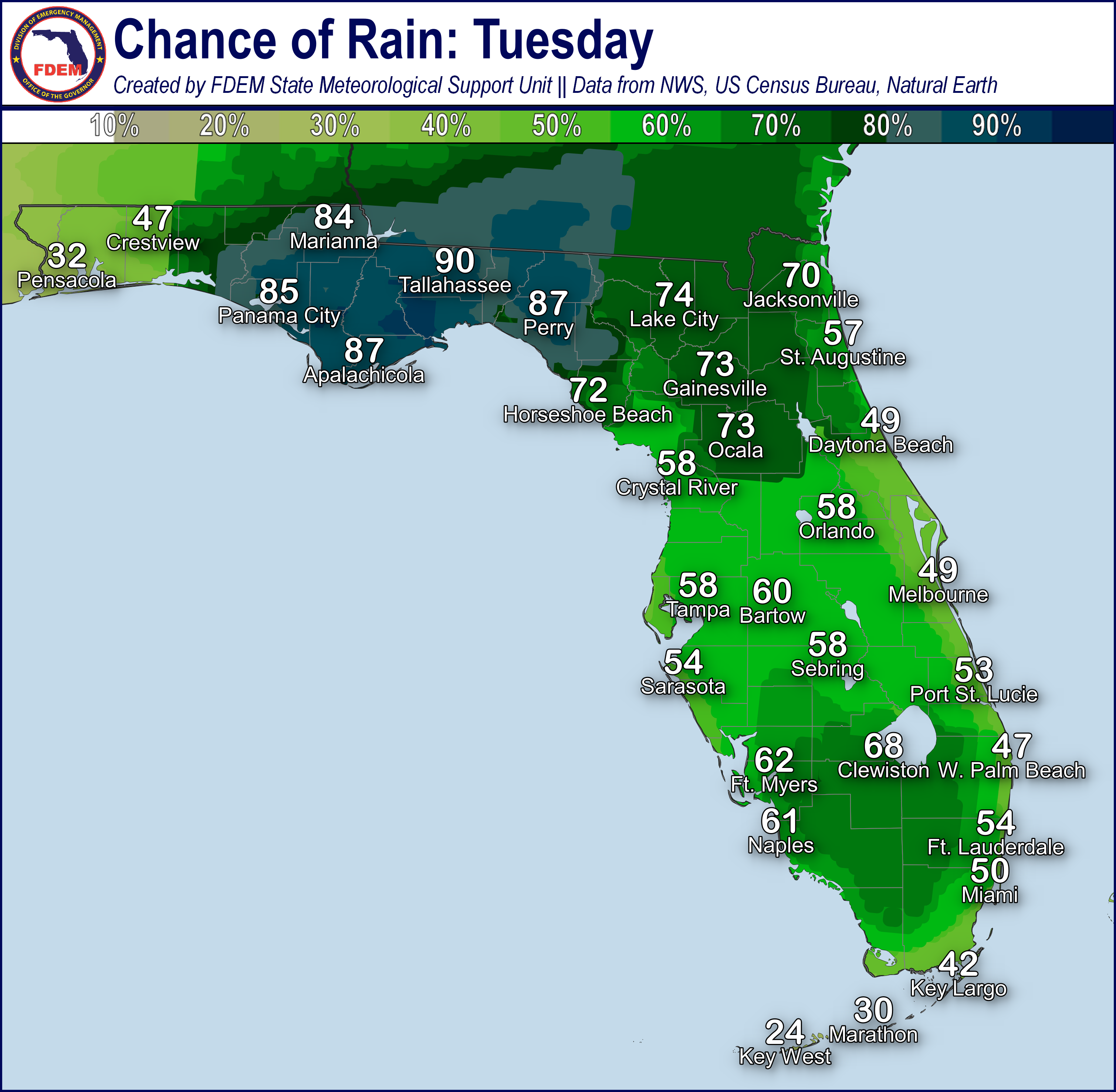
One more potential round of strong to severe thunderstorms is possible this morning and afternoon. Showers and thunderstorms are already developing and tracking eastward through the Panhandle. This line of showers and thunderstorms will continue to track eastward into the Big Bend and Northern Peninsula this morning and afternoon (60-95% chance of rain). Strong to severe thunderstorms producing damaging wind gusts (45-65 mph), instances of hail, isolated tornadoes, and heavy downpours will be possible. Additional storms should form along the Florida Atlantic Coast sea breeze this afternoon with an isolated severe threat possible (45-70% chance of rain).
The Storm Prediction Center is outlooking a Slight Risk (level 2 of 5) for Severe Weather across much of North Florida today with a Marginal Risk (level 1 of 5) along the Nature Coast and East Coast. Flood Watches remain in effect along portions of the Florida Panhandle through this evening as instances of flooding and ponding of water will continue to be possible with additional heavy rainfall over already saturated grounds, urban areas, and low-lying/poor drainage areas today. The Weather Prediction Center (WPC) is outlooking a Slight Risk (level 2 of 4) for Flash Flooding along the Panhandle with a Marginal Risk (level 1 of 4) extending across the Big Bend and into the Northern Peninsula.

High temperatures will remain in the upper 70s to middle 80s across the Florida Panhandle and along the Suwannee Valley thanks to cloudy skies and widespread rainfall. The rest of the state will continue to rise into the 90s with heat indices nearing or reaching triple digits (97-105) through the Peninsula and Keys. Heat Advisories have been issued for South Florida, the Keys, and the Central-East Coast this afternoon as heat indices reach triple digits (106-110) today. Remember to take extra precautions when outside, wear lightweight and loose-fitting clothing, try to limit strenuous activities to early morning or evening, and take action when you see symptoms of heat exhaustion and heat stroke. Despite returning moisture, sensitive wildfire conditions will be possible over areas that continue to see short-term rainfall deficits and ongoing drought conditions due to drier pockets near critical thresholds (40-45%) expected along portions of the interior Peninsula this afternoon. Numerous additional rivers and waterways across North Florida have begun to rise into Action Stage in response to heavy rainfall across the basins over the past week. River Flood Warnings have been issued for multiple Florida Panhandle rivers and waterway as minor flooding is occurring or forecast to occur this weekend and into next week.
Scattered showers will linger into the overnight and into Sunday along the Big Bend and Peninsula (30-75% chance of rain) while the rest of the state begins to dry out as high pressure builds back in along the Eastern U.S. (15-35% chance of rain). Low temperatures will fall into the middle to upper 60s along the Florida Panhandle, 70s along the Peninsula, and low 80s along the Keys. Areas of patchy to locally dense fog will be possible across portions of the state overnight and early Sunday morning.

![]()

Rip Currents: A high risk for rip currents persists along the Florida Panhandle today with a moderate risk along the West-Central Coast. A low risk persists along all other beaches today. For the latest Rip Current Outlook, visit www.weather.gov/beach.
Marine Hazards: 1-2’ wave heights can continue to be expected along the East Coast and Keys this afternoon. Breezy winds developing with the next system will build swells in the Gulf of Mexico, creating wave heights of 1-4’ along the West Coast and Florida Panhandle.
Red Tide has not been observed at or above background levels over the past week.
Coastal Flooding: Coastal flooding is not expected today; however, elevated tides (0.5-0.75’ above normal) may be possible along the Forgotten and Nature Coasts at times as breezy winds persist.
![]()

Tropical cyclone formation is not expected during the next 7 days in the Atlantic Basin.
The National Hurricane Center has begun issuing regular Tropical Weather Outlooks for the 2024 hurricane season as of May 15. These outlooks show areas of possible tropical cyclone development in the next 48 hours and next 7 days. Outlooks are issued every 6 hours at 8am, 2pm, 8pm, and 2am eastern time, or as conditions warrant. The Atlantic Hurricane Season officials begins June 1.
For the latest on the tropics, please visit the National Hurricane Center (NHC) at www.hurricanes.gov.
![]()
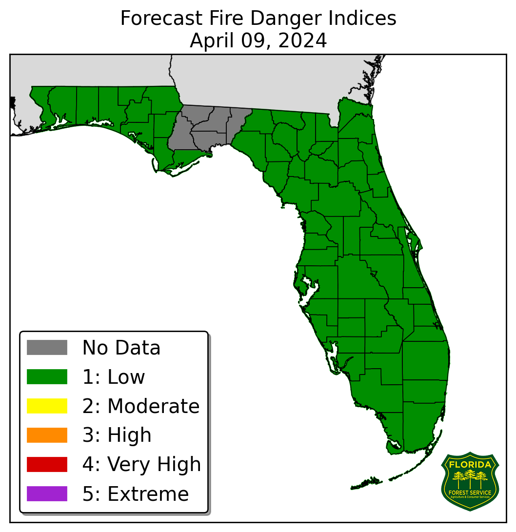
Fire Weather: One more potential round of strong to severe thunderstorms is possible this morning and afternoon. Showers and thunderstorms are already developing and tracking eastward through the Panhandle. Additional storms should form along the Florida Atlantic Coast sea breeze this afternoon with an isolated severe threat possible. Erratic, gusty winds and lightning within thunderstorms may be capable of spreading existing fires or igniting new fires. Wind gusts near 20-30 mph can be expected along the Florida Panhandle at times outside of thunderstorms with 10-20 mph gusts elsewhere. Returning moisture will generally keep relative humidity values above critical thresholds with drier pockets near critical thresholds (40-45%) along portions of the interior Peninsula this afternoon. Sensitive wildfire conditions will be possible over areas that continue to see short-term rainfall deficits and ongoing drought conditions in the Peninsula this afternoon. Heat Advisories have been issued for South Florida, the Keys, and the Central-East Coast this afternoon as heat indices reach triple digits (106-110) today. Heat indices will approach or reach triple digits (97-105) elsewhere across the Peninsula. Areas of patchy to locally dense fog will be possible overnight and early Sunday morning. Fog may further reduce visibilities in areas with ongoing wildfires. According to the Florida Forest Service, there are 39 active wildfires across the state burning approximately 2081 acres.

Drought: While heavy rainfall was observed across portions of the state over the past week, Central and South Florida continues to see very limited rainfall an above normal temperatures (2-4-degress above normal), leading to additional expansions in drought conditions on this week’s update as fire danger is high, and dryness continues to compound. Moderate Drought conditions now span from the West Coast to the East Coast from a line north of Fort Myers to north of West Palm Beach and northward to a line from Sarasota to Melbourne. Abnormally dry (emerging drought) conditions have expanded further along the I-4 corridor and south of Lake Okeechobee to Fort Lauderdale. Continued above normal temperatures and below normal precipitation over the next 6-10 days will likely continue to exacerbate drought conditions.
The Keetch-Byram Drought Index average for Florida is 310 (+6) on a scale from 0 (very wet) to 800 (very dry). There are 13 Florida counties (Brevard, Broward, Charlotte, DeSoto, Glades, Hardee, Highlands, Indian River, Manatee, Martin, Palm Beach, Sarasota and St. Lucie) with an average KBDI over 500 (drought/increased fire danger).
![]()
Flash Flooding: The Weather Prediction Center (WPC) is outlooking a Slight Risk (level 2 of 4) for Flash Flooding along the Panhandle with a Marginal Risk (level 1 of 4) extending across the Big Bend and into the Northern Peninsula. Instances of flooding and ponding water will be possible through the Panhandle, especially for locations that remain saturated from heavy rainfall earlier in the week or that experience multiple rounds of heavy rain and thunderstorm activity. Flood Watches remain in effect along portions of the Florida Panhandle through this evening as instances as another round of heavy rainfall moves through the region today. Widespread rainfall totals of 1-3” are anticipated along the Florida Panhandle with locally higher totals in excess of 3-5” possible.

Riverine Flooding: Portions of several Big Bend and Suwannee Valley rivers (including several portions of the Suwannee River) remain in Action Stage (bank-full). Numerous additional rivers and waterways across North Florida have begun to rise into Action Stage in response to heavy rainfall across the basins over the past week. River Flood Warning have been issued for the Ochlocknee River near Concord (CR-12), Escambia River near Century, Blackwater River near Baker, Shoal River near Crestview, and St. Marks River near Newport on Old Magnolia Rd as minor flooding is occurring or forecast this weekend and into next week. Additional heavy rainfall across the Florida Panhandle this morning and afternoon may lead to further water level rises and additional River Flood Warnings may be issued. There are no addition riverine flood concerns at this time. For more details, please visit the River Forecast Center.
Lake Okeechobee’s average elevation is 13.61 feet, which is within the operational band and 0.34 feet above normal for this time of year.
