RSS 5 Day Weather Outlook
5 Day Statewide Weather Outlook for Fri 5/17 to Tue 5/21
You are subscribed to 5 Day Weather Outlook for Florida Division of Emergency Management. This information has recently been updated, and is now available.
...Multiple Rounds of Severe Weather Anticipated This Afternoon/Evening and Saturday Morning…Slight Risk For Severe Weather Along The Panhandle Today and Across Much of North Florida Saturday…Damaging Wind Gusts (50-70+ MPH), Instances of Hail, And Isolated Tornadoes Possible…Slight Risk for Flash Flooding Along the Panhandle and Western Big Bend Today and Saturday…Flood Watch In Effect For the Western Panhandle Through Saturday; Instances of Flooding and Ponding of Water Possible…Scattered to Numerous Showers and Thunderstorms Persist Along the Peninsula Sunday…Isolated Strong to Severe Thunderstorms and Instances of Flooding May Be Possible…Rain Chances Gradually Drop Off Early Next Week As High Pressure Builds…Heat Indices Near or At Triple Digits Persists Along the Peninsula and Keys Over the Next 5 Days; Heat Advisories In Effect For Miami-Dade County and The Keys This Afternoon…Breezy Conditions Possible At Times Outside of Thunderstorms…Sensitive Wildfire Conditions Along Interior Portions of the Peninsula At Times…Moderate to High Risk For Rip Currents Statewide Over the Next 5 Days…River Flood Warning In Effect For the Ochlockonee River Near Concord for Minor Flooding; Additional River Flood Warnings May Be Needed In The Coming Days Depending On Where the Heaviest Rainfall Occurs Today and Saturday…

5 Day Statewide Weather Outlook for Tue 5/14 to Sat 5/18
You are subscribed to 5 Day Weather Outlook for Florida Division of Emergency Management. This information has recently been updated, and is now available.
…Scattered Showers and Thunderstorms Linger Through the Peninsula This Afternoon…Isolated Strong to Severe Thunderstorms Cannot Be Ruled Out…Showers and Thunderstorms Across the Peninsula Along and Ahead of A Frontal Boundary Wednesday…Marginal Risk to Slight Risk For Severe Weather and Marginal Risk for Flash Flooding Along the Northern and Central Peninsula…Isolated Damaging Wind Gusts, An Isolated Tornadoes, Isolated Instances of Hail, and Localized Heavy Downpours Possible…Drier Conditions Return Thursday Along With Sensitive to Locally Elevated Wildfire Conditions Across Interior Central Florida…Rain Chances Return Friday and Saturday With The Next Low-Pressure System…Marginal to Slight Risk For Flash Flooding Along Florida Panhandle Friday and Marginal Risk Across North Florida Saturday…Strong to Severe Thunderstorms Possible…Breezy Winds Persist Statewide Outside of Thunderstorms, Calming Thursday and Friday Before Re-Strengthening Saturday…Moderate to High Risk for Rip Currents Nearly Statewide Over the Next 5 Days…Numerous Rivers and Waterways Across North Florida Forecast to Rise Into Action Stage Over the Next 5 Days; Several Already Elevated Rivers May Reach Minor Flood Stage…
...Have A Great Rest of The Week!...

5 Day Statewide Weather Outlook for Fri 5/10 to Sat 5/14
You are subscribed to 5 Day Weather Outlook for Florida Division of Emergency Management. This information has recently been updated, and is now available.
...Isolated to Scattered Showers and Thunderstorms Linger Statewide This Afternoon Following Active Weather Observed This Morning…Marginal Risk for Severe Weather Remains in Place Across Much of North Florida and South to I-4; Damaging Wind Gusts, Hail, and Heavy Downpours Remain Possible…Calmer and Slightly Cooler Conditions Expected This Weekend…Rain Chances and Possibility for Severe Weather Returns Early Next Week…Marginal to Slight Risk for Flash Flooding Across North Florida Monday and Tuesday…Wind Gusts Upwards of 20-30 MPH Outside of Thunderstorms Today, Calming This Weekend and Re-Strengthening Early Next Week…Heat Indices Approaching and Reaching Triple Digits Across Portions of Central and South Florida Through the Period…Red Flag Warnings In Effect For Portions of West-Central Florida This Afternoon…Elevated to Locally Critically Wildfire Conditions Across Portions of Central and South Florida and Sensitive to Locally Elevated Wildfire Conditions Across North Florida At Times Over the Next 5 Days…Moderate to High Risk For Rip Currents Generally Statewide Over the Next 5 Days…
…Have a Wonderful Weekend and Stay Safe!...

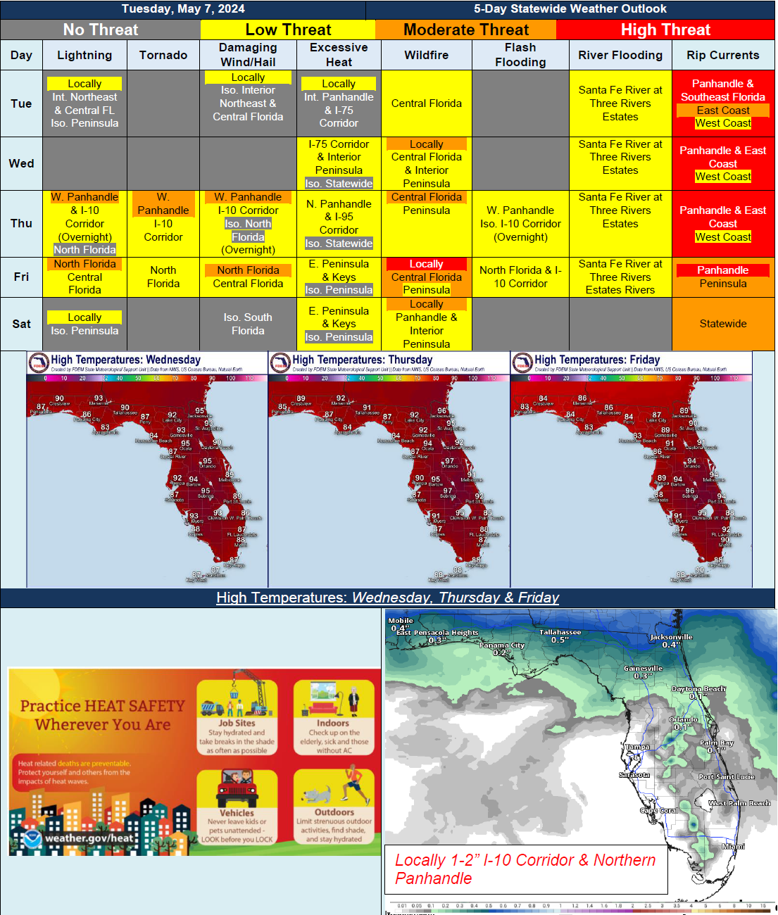
5 Day Statewide Weather Outlook for Tue. 5/7 to Sat/ 5/11
You are subscribed to 5 Day Weather Outlook for Florida Division of Emergency Management. This information has recently been updated, and is now available.
…Warm and Dry Conditions Building Statewide…Record Heat and Near Triple Digit Heat Index Values…Increasing Shower and Thunderstorm Activity Across Panhandle and North Florida Late Thursday and Into Friday Ahead of Cold Front Sweeping Through…Strong to Severe Thunderstorms Possible Bringing Isolated Tornadoes, Damaging Wind Gusts and Heavy Downpours…Localized Flash Flooding Possible Within Heavy Downpours…Elevated Wildfire Conditions Developing Across Central and Interior Peninsula Later in the Week Due to Warm, Dry and Breezy Conditions…
5 Day Statewide Weather Outlook for Fri 5/3 to Tue 3/7
You are subscribed to 5 Day Weather Outlook for Florida Division of Emergency Management. This information has recently been updated, and is now available.
...Isolated to Scattered Showers and Thunderstorms Nearly Statewide Over the Next 5 Days Thanks to Afternoon Sea Breezes and Upper-Level Disturbances Moving Through the Southeast U.S....Isolated Strong to Severe Thunderstorms Cannot Be Ruled Out During Peak Heating Hours…Localized Instances of Flooding and Ponding of Water Possible In Locally Heavy Downpours…Drier Conditions Begin to Return Tuesday As High Pressure Builds Back In…Warm Temperatures Persist Through the Period…Wind Gusts of 15-25 MPH Possible With Sea Breezes Each Day…Sensitive to Locally Elevated Wildfire Conditions In West-Central Florida Today; Locally Sensitive Wildfire Conditions Through the Weekend…Moderate to High Risk For Rip Currents Along Florida Panhandle and East Coast…A River Flood Warning Remains In Effect For the Santa Fe River At Three Rivers Estates…Patchy to Locally Dense Fog Possible Across North and Central Florida Through the Weekend…
…Have A Great Weekend!...

