Current Weather Outlook
Statewide weather outlook from Florida Division of Emergency Management Meteorology
Saturday, March 29, 2025
...Southerly Flow Increasing Moisture Across the State and An Approaching Upper-Level Disturbance Will Allow Isolated to Scattered Showers and Thunderstorms to Develop Statewide Today and Tonight...Isolated Strong to Severe Thunderstorms May Be Possible, Primarily During Peak Heating Hours of the Day and With Sea Breeze Collisions...Isolated Instances of Flooding and Ponding of Water Cannot Be Ruled Out With Locally Heavy Downpours...Breezy Winds Near 10-15 MPH With Gusts Near 15-25 MPH To Persist Statewide Today and Into Tonight...Sensitive to Locally Elevated Wildfire Conditions Continue Across North and Central Florida This Afternoon With Lingering Dry Air...Hazardous Beach and Boating Conditions and Elevated Surf Expected Nearly Statewide...High Risk for Rip Currents Along the East Coast and Florida Panhandle...Areas of Patchy to Locally Dense Fog Possible Across North and Central Florida Overnight Into Early Sunday Morning...
Updated at 9:25 AM EST
Today's Threats:
|
No Threat |
Low Threat |
Medium Threat |
High Threat |
|
Lightning |
Tornado |
Damaging Wind/Hail |
Flash Flooding |
Riverine Flooding |
Fire Weather |
Fog (Overnight) |
Rip Currents |
|
Locally Statewide |
Locally Iso. Statewide |
Iso. Statewide |
|
Locally N & Central FL |
Locally Iso. N & Central FL |
FL Panhandle & E-Coast West Coast |
![]()
Weather Summary for the Next 24 Hours:
The area of high pressure that has maintained mostly dry conditions across the state over the last few days will push further eastward over the Western Atlantic today. An unsettled weather pattern will begin to develop statewide today as southerly flow increases moisture across the state and an upper-level disturbance approaches from the west, allowing isolated to scattered showers and thunderstorms to develop nearly statewide throughout the day (30-60% chance of rain). Isolated strong to severe thunderstorms capable of producing frequent lightning, gusty winds, and heavy downpours may be possible at times, primarily during the peak heating hours of the day with the help of the sea breeze collisions. Despite no organized risk for flash flooding, localized instances of flooding and ponding of water cannot be ruled out with locally heavy downpours, especially over urban and low-lying/poor drainage areas. A swath of drier air lingering across the Big Bend and Northern Peninsula will work to suppress shower and thunderstorm activity today with only isolated showers possible (10-30% chance of rain).
High temperatures will rise into the middle 70s to middle 80s nearly statewide this afternoon with portions of the Western Peninsula reaching into the upper 80s. Breezy southeasterly winds near 10-15 mph with gusts near 15-25 mph will persist statewide today. Lingering dry air will continue to create sensitive to locally elevated wildfire conditions across portions of North and Central Florida this afternoon.

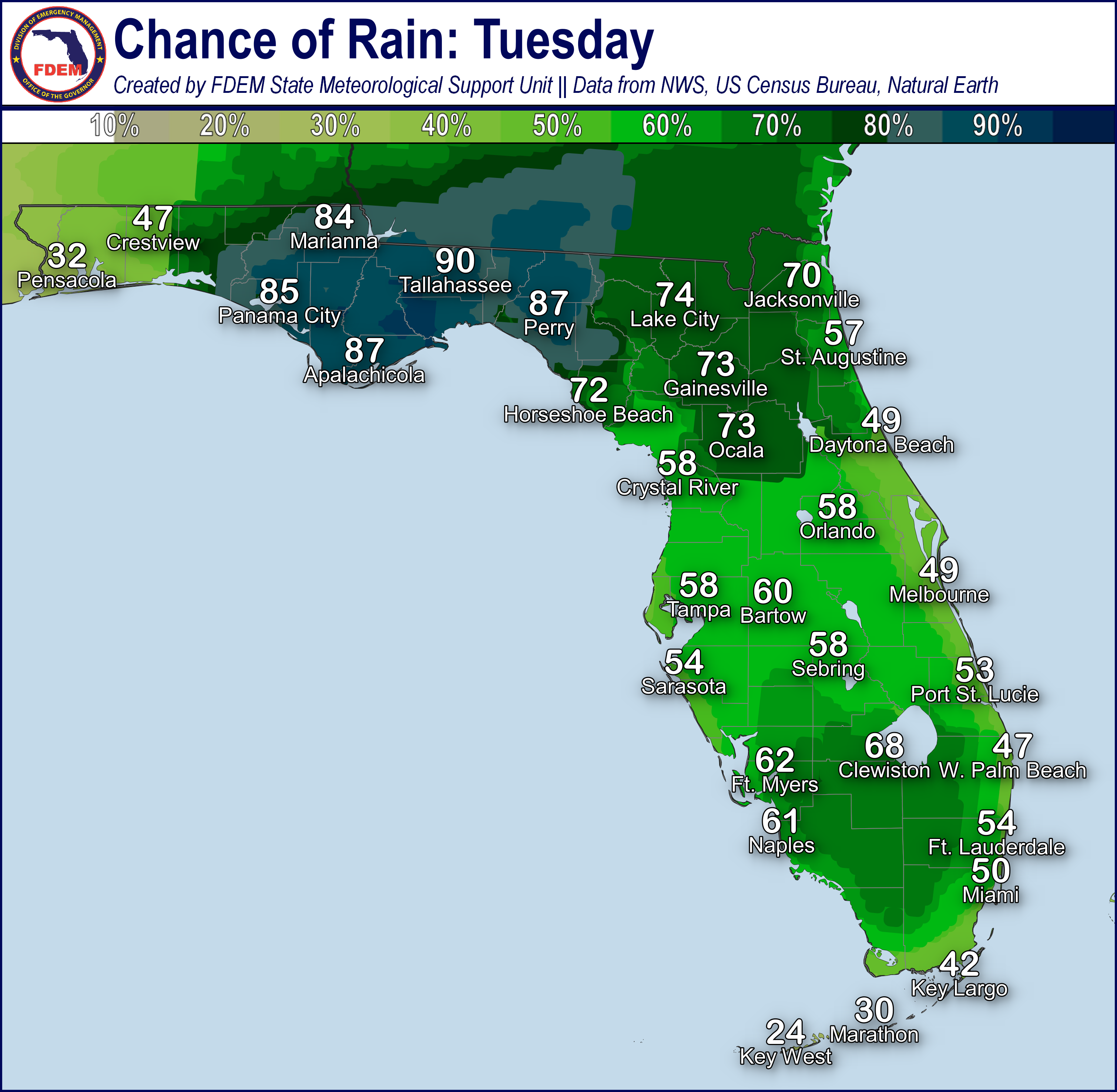
Scattered showers and thunderstorms will continue into the overnight hours across the state, spreading into the Big Bend and Northern Peninsula as well as moisture continues to increase (25-55% chance of rain). A locally strong to severe thunderstorm or two and isolated instances of flooding and ponding of water cannot be ruled out overnight.
Low temperatures will remain in the middle 60s across North Florida, upper 60s to low 70s across Central and South Florida, and low to middle 70s along the Southeast Coast and Keys tonight. Breezy southeasterly winds will persist tonight, remaining near 5-10 mph with gusts near 10-20 mph. Areas of patchy to locally dense fog will be possible across North and Central Florida overnight into early Sunday morning.

![]()

Rip Currents: Breezy onshore winds and ocean swells along the East Coast and Florida Panhandle will give way to high risk for rip currents today. A low risk persists along the West Coast; however, a locally moderate risk cannot be ruled out as ocean swells shift southward and begin to impact the coastline. With spring break season is full-swing, messaging regarding rip currents and dangerous surf conditions should be maintained for visitors and tourists. For the latest Rip Current Outlook, visit www.weather.gov/beach.
Marine Hazards: Breezy winds and ocean swells will maintain hazardous beach and boating conditions nearly statewide today. Large breaking waves near 4-7’ can be expected to persist along the Panhandle Florida’s Atlantic Coast today. High Surf Advisories have been issued for the Western Panhandle from 1 PM EDT this afternoon until 1 AM EDT Sunday morning for large breaking waves of 4-6’ expected in the surf. Additional High Surf Advisories may be issued as conditions warrant. 2-4’ waves can be expected along the Big Bend and West Coast.
Red Tide has been observed at background levels in 1 samples collected from Northwest Florida (Gulf County) over the past week (valid 3/29). There have been no reports of respiratory irritation or fish kills suspected to be related to red tide.
Coastal Flooding: Astronomically high tides with the upcoming New Moon combined with breezy winds and ocean swells along Florida’s coastlines may result in instances of elevated tides (0.25-1’ above normally dry ground) near and at times of high tide today. Localized instances of minor coastal flooding cannot be ruled out.
![]()
Fire Weather: An unsettled weather pattern will begin to develop statewide today and tonight as high pressure drifts further eastward into the Western Atlantic and an upper-level wave approaches from the west. Isolated strong to severe thunderstorms may be possible, primarily during the peak heating hours of the day. Thunderstorms may be capable of producing frequent lightning and erratic gusty winds. Breezy southeasterly winds near 10-15 mph with gusts near 15-25 mph will persist statewide today. Lingering dry air will continue to create sensitive to locally elevated wildfire conditions across portions of North and Central Florida this afternoon. Red Flag Warnings criteria is not expected at this time. Breezy southeasterly winds will persist tonight, remaining near 5-10 mph with gusts near 10-20 mph. Areas of patchy to locally dense fog will be possible across North and Central Florida overnight into early Sunday morning. Fog may further reduce visibilities in areas with ongoing wildfires. According to the Florida Forest Service, there are 66 active wildfires across the state burning approximately 28,507.61 acres.

Drought: Most of the Southeast U.S. experienced a dry, breezy week, leading to a rash of wildfires and general increases in the coverage of Abnormally Dry (emerging drought) and Moderate to Severe Drought conditions on this week’s Drought Monitor update (valid 3/27). Severe Drought condition also persist across much of South Florida and north of the I-4 corridor across portions of the Nature Coast. Abnormally Dry to Moderate Drought conditions expand elsewhere across the Peninsula from a line from Horseshoe Beach to Gainesville to St. Augustine and southward through the far southern Peninsula. In Southern Florida, the 344 Fire near Homestead grew to nearly 27,000 acres, with containment reaching 80% by 3/25. The Climate Prediction Center (CPC) is outlooking above normal temperatures and slightly above normal rainfall across the Peninsula over the next week or so which may allow drought conditions to hold steady.
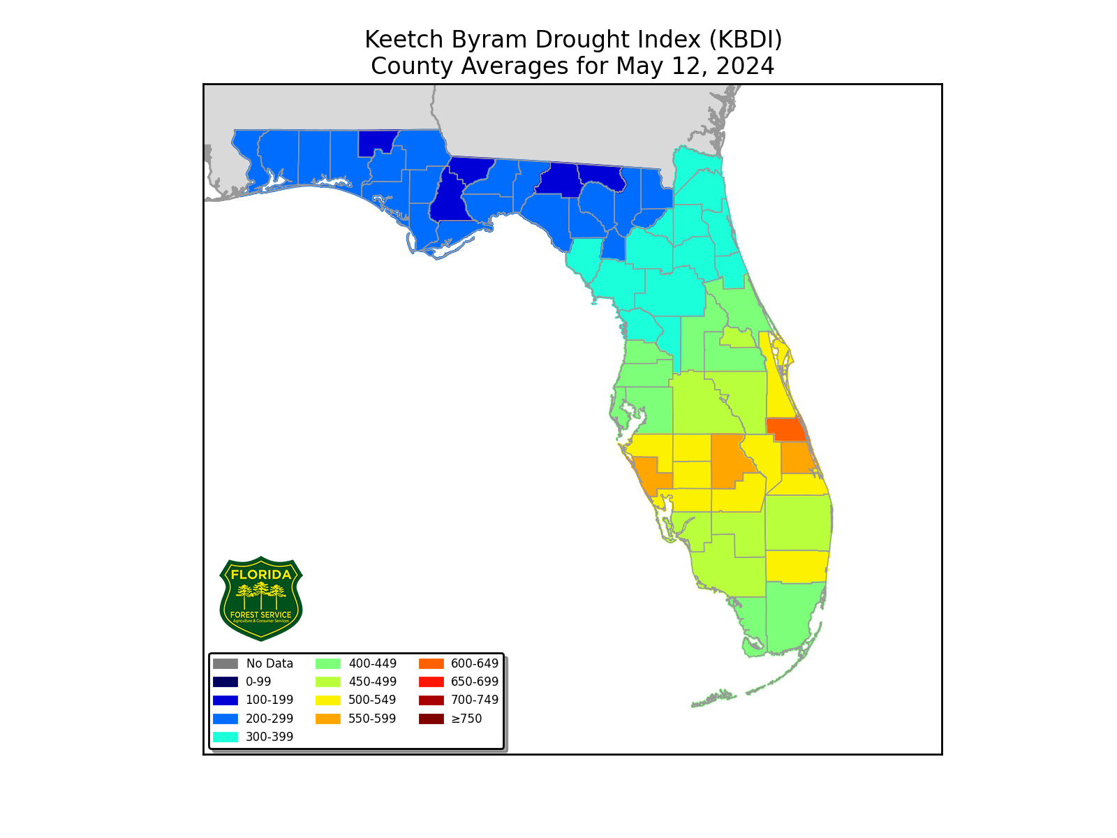
The Keetch-Byram Drought Index average for Florida is 347 (+8) on a scale from 0 (very wet) to 800 (very dry). There are 17 Florida counties (Broward, Charlotte, Collier, DeSoto, Glades, Hardee, Hendry, Hernando, Highlands, Lake, Lee, Manatee, Miami-Dade, Monroe, Palm Beach, Sarasota, and Sumter) with an average KBDI over 500 (drought/increased fire danger).
![]()
Flash Flooding: An unsettled weather pattern will begin to return statewide today as high pressure drifts further eastward into the Western Atlantic and an upper-level wave approaches from the west. Despite no organized risk for flash flooding, localized instances of flooding and ponding of water cannot be ruled out with locally heavy downpours, especially over urban and low-lying/poor drainage areas. Widespread rainfall totals are expected to remain near or below 1”; however, stronger shower and thunderstorm activity will be capable of producing locally higher rainfall totals near 1-3” in a relatively short period of time.

Riverine Flooding: Portions of the Aucilla and Santa Fe rivers remain within Action Stage (bank-full) as water levels continue to slowly decline following rises from recent heavy rainfall. There are no additional riverine concerns at this time. For more information, visit the River Forecast Center.
Lake Okeechobee’s average elevation is 12.62 feet, which is within the operational band and is 1.71 feet below normal for this time of year.